Stanford researchers develop new method of estimating biodiversity based on tree cover
Scientists used tree cover maps and on-the-ground observations to measure biodiversity in Costa Rica. The results generated a method of modeling biodiversity across tropical landscapes.
Historically, conservationists have protected species by placing large swaths of land into preserves and parks. However, only 13 percent of the world’s land area is located in protected natural land. Most of the planet’s species live in ecological gray areas, located within a gradient where one end is pristine wilderness, the other a parking lot.

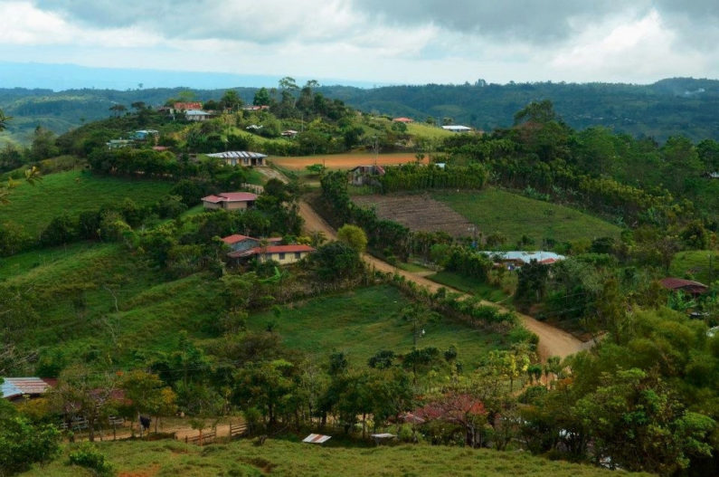
Stanford researchers discovered that in agricultural areas of Costa Rica, increased tree cover corresponds with increases in biodiversity. (Image credit: David Spangenburg)
Protecting species in these gray areas is a challenge because there’s no way to measure biodiversity without time-consuming field surveys. With no way to estimate biodiversity, making decisions for protecting habitat and species is difficult. Researchers at Stanford, through extensive observations, mapping and analysis, have now generated a method of estimating biodiversity based on tree cover. The results can be used by policymakers to help protect biodiversity and endangered species.
“We’ve created a framework for counting something previously uncountable,” said Chase D. Mendenhall, a postdoctoral research fellow in biology at Stanford. Mendenhall is a lead author in a new study, to be published Oct. 24 in the Proceedings of the National Academy of Sciences, that has created a quantitative measure of biodiversity across agricultural and urban landscapes.
The key: trees
Over a series of three- to six-month field sessions across 10 years, Mendenhall’s team of 15 researchers hiked across the hilly tropical agricultural landscape of Coto Brus, an area in Costa Rica. In an ecological gradient from protected forest to treeless pasture, the team made a total of 67,737 observations of 908 species, comprised of understory plants, non-flying mammals, bats, birds, reptiles and amphibians.
The scientists then plotted their plant and animal observations on detailed, fine-scale maps from Google Earth aerial photographs.

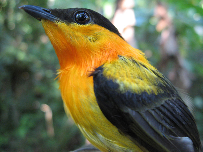
Birds like this orange-collared manakin are more common in areas with increased tree cover. (Image credit: Chase Mendenhall)
When they analyzed the results, the importance of tree cover became clear. For four of the six species groups (plants, non-flying mammals, bats and birds), scientists saw a significant increase in the number of species with increasing tree cover visible on Google Earth maps. At a single point, Mendenhall’s new model predicts biodiversity in the region within a 30- to 70-meter radius and demonstrates how the number and kind of species change as trees are added to plots of land.
“All the animals agreed: trees are great,” Mendenhall said.
The analysis showed adding a single tree to pasture could boost, for example, the species number of bird species from near zero to 80. After this initial sharp increase, adding trees continues to add new species, but more gradually. As the stand of trees approaches 100 percent cover within the area of interest, endangered and at-risk species like wildcats and deep forest birds begin to appear.
“This is a win-win situation for planting trees and reforestation. One tree will increase the number of species quickly and planting a forest that fills in 100 percent of the area brings in the really charismatic species most at risk of extinction,” Mendenhall said.
While the researchers found strong relationships between trees and species in Coto Brus, the question of greater applicability remained. To address this, Mendenhall and his colleagues compared their results to 90 similar studies across Latin America.
All the other studies were in line with what Mendenhall found in Costa Rica, demonstrating similar relationships between biodiversity and tree cover. The comparison across Latin America showed that the team’s results were applicable throughout tropical agricultural landscapes.
A win for biodiversity
There are two general ways to value biodiversity: the total number of species and the number of at-risk or rare species. This study shows that planting single trees or regenerating large tracts of forest increases both values of biodiversity – both rely on adding more trees to the landscape.
“Biologists all work with different animals. Some view the world through birds, some through bats. I’m trying to get a consensus that one thing all biologists can recommend to policymakers interested in halting climate change, protecting water, and safeguarding biodiversity is to plant, preserve and regenerate trees in the warm, wet areas of the world where most biodiversity exists,” Mendenhall said.
In practice, farmers can achieve a significant increase in biodiversity just by planting a few trees in their fields. Additionally, a reforestation project leader can use the model to figure out how many trees to add in order to bring back a rare or endangered species.
“We’re giving people a way of measuring biodiversity, so that they can place their own value on it,” Mendenhall said.
The model produced by the study could eventually be used in policymaking. Biodiversity can be factored into land use decisions, adding another variable to ecosystem services. Along with securing clean water and removing carbon from the atmosphere, the ability of trees to support life could be included in planning decisions.
“We know that planting trees along rivers protects water and sucks up atmospheric carbon. Now we’re also showing how many species you can add in the process,” Mendenhall said.
Additional Stanford co-authors on the paper include Analisa Shields-Estrada, former Stanford undergraduate student; Arjun Krishnaswami, master’s candidate in civil and environmental engineering; and Gretchen C. Daily, Bing Professor in Environmental Science and senior fellow at the Stanford Woods Institute for the Environment.
The work was funded by the Moore Family Foundation, Peter and Helen Bing, Ralph and Louise Haberfeld, a Bing Fellowship in Honor of Paul Ehrlich, an NSF Graduate Research Fellowship, and a NatureNet Science Fellowship through the Nature Conservancy.
